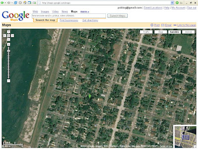
Only a few mouse clicks away, a total revision of the recent history of the Big Easy is on offer from Google Inc's popular map portal.Some people interviewed in the article suggest this is a conspiracy:
The company has replaced post-Hurricane Katrina satellite imagery of New Orleans with pictures taken before the storm, leaving locals feeling they are in a time loop.
The virtual Potemkin village is fuelling the imagination of frustrated locals.I don’t know about a conspiracy, but it is inaccurate to have old satellite images of New Orleans. The Lower 9th north of Claiborne doesn’t look like this anymore:
"I think a lot of stuff they're doing right now is smoke and mirrors because tourism is so off," Gerica said. "It might be somebody's weird spin on things looking better."
"Is Google part of the conspiracy?" Henry asked, alluding to widespread feelings among many New Orleans blacks that they are being neglected in the rebuilding.
"Why these images of pre-Katrina? Seems mighty curious."
[UPDATE]

Or Lakeview. Or Mid-City. Gentilly. Etc.
If Google were to update its satellite pics of New Orleans and the area, it would be a useful tool for residents here and everywhere to follow the rebuilding process. The nation could see how all their billions upon billions upon billions in tax dollars is being spent in this part of the world. Or not spent.
Of course, Google can do whatever they want with their websites. My big issue is the inaccuracy of the images. They might as well put up an artist’s rendering of the way places like Lakeview and the Lower 9th used to look near the breaches.
Then again, rather than a virtual tour, you could always come and see the real thing.
4 comments:
I was just wondering out loud to everyone at work about this myself the other day.
On the one hand, it's kind of a pleasing bit of nostalgia. On the other hand, what the hell!
None of the proffered conspiracy theories are very convincing to me. I can't figure what interest Google would have in intentionally misrepresenting the city. I know the local tourist industry likes to lie to people. I know the Bush Admin likes to lie to people. But what could Google maps have to do with any of that? It's just weird.
I would guess that they were replaced because Google most likely has nothing newer than the photos taken while the city was actually under water. I might be wrong about that, but the satellite photos are not updated very often. Even in large cities (which have newer photos than most of the country) the images tend to be several year old. The last time I looked at the images of Chicago, for example, they were about 3-4 years old. Given the choice between images from before the storm and images of the city under water, it seems reasonable to have chosen to go with the older photos.
I don't believe it's at all reasonable to choose images before the storm. That is not reality - period. As for older images of other cities, they didn't suffer the catastrophe we did.....not alot of difference. Big difference here.
What happened here doesn't need to be "air-brushed" to be asthetically pleasing to the viewer. I think this is just plain weird, as Jeffry says. Actually, I think it's creepy. Very creepy.
This is very interesting.
This can be tracked down. The question is how badly do you want to know? And then what do you want to do with the information?
Post a Comment